This guide contains affiliate links. If you buy through them, Arrive Outdoors may earn a commission at no extra cost to you. Learn more.
Hiking in the Colorado Rockies means alpine lakes, wildflower basins and more than 50 summits over 14,000 feet, but two things set the rules: altitude and afternoon lightning. Acclimatize for a day or two before going high, start early and be below treeline by early afternoon in summer, and plan most high hikes for July through September. The best-known regions are Rocky Mountain National Park, the Indian Peaks, the Front Range 14ers near Denver, the Maroon Bells near Aspen and the San Juan Mountains in the southwest, and several popular areas now require timed-entry or parking reservations in peak season.
For seasons, campgrounds and top trails in Colorado's flagship park, see the Rocky Mountain National Park guide. For a very different Colorado hike, the Great Sand Dunes guide covers climbing North America's tallest dunes with a 14,000-foot range behind them.
Colorado Rockies hiking regions compared
| Region | Base towns | Known for | Example hikes | Access notes |
|---|---|---|---|---|
| Rocky Mountain National Park | Estes Park, Grand Lake | Alpine lakes, tundra, elk, Longs Peak | Emerald Lake, Sky Pond, Chasm Lake | Timed entry in peak season; wilderness permits for overnights |
| Indian Peaks Wilderness | Nederland, Ward, Boulder | Lakes and 12,000–13,000 ft peaks just south of RMNP | Lake Isabelle, Mount Audubon | Brainard Lake area uses summer reservations; overnight permits in summer |
| Front Range 14ers | Georgetown, Idaho Springs, Breckenridge | The closest 14ers to Denver | Mount Bierstadt, Grays and Torreys, Quandary Peak | Very crowded on summer weekends; some parking reservations |
| Maroon Bells | Aspen, Snowmass | Colorado's most photographed peaks; aspen color | Maroon Lake, Crater Lake, Four Pass Loop | Shuttle or reserved parking in season; permits in the wilderness |
| San Juan Mountains | Ouray, Silverton, Telluride, Durango | Rugged volcanic peaks, wildflower basins, the state's biggest wilderness | Ice Lakes Basin, Blue Lakes, Chicago Basin | Long drives and rough roads; check current permit rules for popular basins |
Rocky Mountain National Park
Much of the park lies above 9,000 feet, and Trail Ridge Road crosses the tundra at over 12,000 feet. The Bear Lake corridor is the hub for classic lake hikes: Nymph, Dream and Emerald Lakes, Alberta Falls, and the longer trek up Glacier Gorge to The Loch and Sky Pond. Chasm Lake sits beneath the sheer East Face of Longs Peak, and the west side around Grand Lake is quieter.
Longs Peak (14,259 ft) is the park's only 14er. Its standard Keyhole Route is a long, exposed class 3 scramble, typically in condition only from mid-summer to early fall, and most parties start well before dawn.
The park has used a timed-entry reservation system during its busiest months, with a separate reservation for the Bear Lake Road corridor. Rules, dates and hours change by season; check nps.gov/romo and Recreation.gov before you go.
Indian Peaks Wilderness
Just south of the national park, the Indian Peaks offer similar scenery with no park entrance. The Brainard Lake Recreation Area near Ward is the busiest gateway, with trails to Lake Isabelle and up Mount Audubon (13,223 ft), a non-technical walk-up with huge views of the Divide. Brainard has required advance reservations for vehicles in summer. Overnight camping in the Indian Peaks requires a permit during the summer season. Details are with the Arapaho and Roosevelt National Forests.
Front Range 14ers near Denver
The 14ers closest to Denver are the most popular and the most common first 14ers:
- Mount Bierstadt from Guanella Pass: a class 2 trail with a relatively short route, and very crowded on summer weekends.
- Grays and Torreys Peaks: two 14ers linked by a saddle, both class 1–2 by the standard trail. The Kelso Ridge on Torreys is a class 3 alternative.
- Quandary Peak near Breckenridge: the east ridge is a class 1 trail. The trailhead has used paid or reserved parking and a shuttle in summer.
- Mount Blue Sky (formerly Mount Evans): the summit road has required timed vehicle reservations in summer; check current rules if you plan to drive part of the way.
Weekday starts and dawn arrivals make a big difference to parking and crowding on all of these.
Maroon Bells
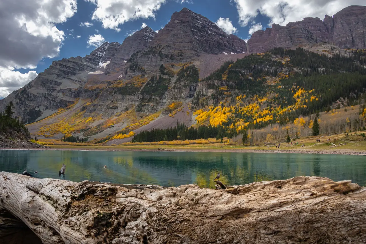
The twin peaks of the Maroon Bells reflected in Maroon Lake are Colorado's most famous view. In summer and fall, private vehicles on Maroon Creek Road are restricted during the day, and access is by the RFTA shuttle bus or reserved parking; check the White River National Forest site for current reservations.
- Maroon Lake Scenic Trail: an easy lakeside walk.
- Crater Lake: a moderate climb to a lake directly beneath the Bells, roughly 3.5–4 miles round trip.
- Four Pass Loop: a classic multi-day backpacking loop of roughly 26 miles over four passes above 12,000 feet. Overnight use in the Maroon Bells-Snowmass Wilderness has its own permit and camping rules.
The Maroon Bells themselves are not beginner peaks. Their rock is notoriously loose and the routes are class 3–4 with serious rockfall danger; see our class 4 scramble guide for what that rating means.
San Juan Mountains
The San Juans in southwest Colorado are the most rugged range in the state, with dozens of 13ers and 14ers, the Weminuche Wilderness (Colorado's largest) and wildflower basins that peak in July and August.
- Ice Lakes Basin near Silverton: a steep, popular climb to vivid blue lakes. Heavy use has brought new parking and permit discussions to popular basins like this one, so check the San Juan National Forest site for current rules before going.
- Blue Lakes near Ridgway: three turquoise lakes beneath Mount Sneffels.
- Chicago Basin: a backpacking destination reached by the Durango & Silverton train, with three 14ers above the basin.
Expect long drives on mountain highways and, for many trailheads, rough dirt roads that need high clearance.
Altitude sickness and acclimatization
Most Colorado trailheads sit between 8,000 and 11,000 feet, and summits reach above 14,000 feet, where each breath carries roughly 40 percent less oxygen than at sea level. Altitude illness can affect anyone, regardless of fitness.
Symptoms of acute mountain sickness (AMS)
- Headache, plus one or more of: nausea or loss of appetite, fatigue or weakness, dizziness, poor sleep
- Usually starts 6–12 hours after arriving at altitude
How to acclimatize
- Sleep a night or two at an intermediate elevation, such as Denver (5,280 ft) or a foothills town, before hiking high.
- Start with a lower, shorter hike on your first day and save 14ers for later in the trip.
- Increase your sleeping elevation gradually. The CDC advises that above about 9,000 feet you avoid raising your sleeping elevation by more than roughly 1,600 feet (500 m) per day.
- Drink water, eat carbohydrates and skip alcohol for the first day or two.
- If you've had altitude illness before, talk to a doctor about preventive medication.
Afternoon thunderstorms: start early
From roughly late June through August, the summer monsoon brings thunderstorms that build over the peaks most afternoons. Lightning is a serious, well-documented hazard on Colorado's peaks, and above treeline you are often the tallest object around.
- Start early, often between 3 and 6 a.m. for 14ers, so you can summit by late morning.
- Set a turnaround time and keep it, even if you're close to the top.
- Watch the sky, not the clock. Cumulus clouds towering upward by mid-morning are a sign to descend.
- If you hear thunder, you're within striking distance. Get off summits and ridges and head for lower terrain; there's no truly safe place above treeline. See the National Weather Service lightning safety pages.
- Carry layers. Storms bring hail, rain and temperature drops of 20°F or more within minutes.
14ers basics and class ratings
Colorado's 14ers (peaks over 14,000 feet) are graded with the Yosemite Decimal System's classes, which describe the hardest terrain on the route:
| Class | What it means | Colorado examples (standard routes) |
|---|---|---|
| Class 1 | Hiking on a defined trail | Quandary Peak (east ridge), Grays Peak, Handies Peak (from American Basin) |
| Class 2 | Rougher trail or off-trail talus; occasional hands for balance | Mount Bierstadt, Mount Sherman |
| Class 3 | Scrambling with hands; a fall could cause serious injury | Longs Peak (Keyhole Route), Kelso Ridge on Torreys |
| Class 4 | Steep, exposed climbing; a fall could be fatal; some parties use a rope | Capitol Peak (Knife Edge), Maroon Bells traverse |
Before attempting a class 3 route, read our class 3 scramble guide; for class 4, see the class 4 guide. Ratings describe dry, summer conditions. Snow, ice or wet rock can make a class 2 route far harder.
14er checklist
- Check the forecast the night before and the morning of; postpone if storms are forecast early.
- Bring the ten essentials, including a headlamp for the pre-dawn start, a map, and a warm, waterproof layer.
- Carry at least 2–3 liters of water and treat any refills (our Sawyer Squeeze guide covers filtering).
- Tell someone your route and return time; cell coverage is spotty. Read what to do if you get lost.
- Wear sturdy footwear for talus and pack sun protection: UV is intense at altitude.
- Know that the descent is where most people get tired and hurt. Save energy for it.
A packable waterproof rain jacket and trekking poles for the long talus descents are the two items most worth adding to a lowland day kit.
Permits, timed entry and reservations
Several of Colorado's most popular trailheads now limit access in peak season. The details change every year, so treat this as a list of places to check rather than current rules:
- Rocky Mountain National Park: timed-entry reservations during the busy season; wilderness permits for all overnight trips (nps.gov/romo).
- Brainard Lake (Indian Peaks): vehicle reservations in summer; overnight permits for the wilderness.
- Maroon Bells: shuttle or reserved parking; overnight camping rules in the wilderness.
- Hanging Lake in Glenwood Canyon: a permit is required to hike.
- Mount Blue Sky and Quandary Peak: road or parking reservations have applied in summer.
- Great Sand Dunes: no permit for day hiking on the dunes; backcountry camping requires a permit (nps.gov/grsa).
Leave No Trace in the high country
Alpine tundra grows only a few weeks a year and can take decades to recover from trampling. Follow the Leave No Trace principles, with a few Colorado-specific habits:
- Stay on the trail, even when it's muddy, and don't cut switchbacks. On tundra without a trail, spread out on durable rock rather than walking single file.
- Pack out everything, including food scraps and toilet paper. On busy 14ers with no cover, carry a waste bag.
- Camp at least 200 feet from lakes and streams and use established sites; many areas also restrict campfires, especially above treeline.
- Give wildlife space. Elk, moose and mountain goats are large and unpredictable; never feed marmots or pikas.
- Leash or leave dogs home, and note dogs aren't allowed on trails in Rocky Mountain National Park.
Best months for hiking in the Colorado Rockies
| Months | Conditions | Best for |
|---|---|---|
| May–June | Lower trails open; high trails and passes still snowy; snowmelt rivers run high | Foothills, lower canyons, Great Sand Dunes (Medano Creek usually flows in late spring) |
| July–August | Most high trails snow-free by mid-July; wildflowers peak; daily afternoon storms | 14ers with dawn starts, alpine lakes, San Juan wildflower basins |
| September | Usually drier and more settled; cold nights; aspens turn in the second half | Long alpine days, Maroon Bells and aspen hikes, fewer crowds midweek |
| October | Early snowstorms likely up high; short days | Lower-elevation hikes, early-October aspens in some areas |
| November–April | Snow and avalanche terrain up high | Snowshoeing on low-angle trails; avalanche training needed for steep terrain |
On the Great Sand Dunes, the sand surface can get dangerously hot on summer afternoons, so hike the dunes at dawn or in the evening. For more Colorado options, Grand Mesa offers cooler high-plateau hiking among hundreds of lakes. Check average temperatures on our July and September weather guides, and build a day-hike or backpacking list with the Packing List Generator.
Frequently asked questions
When is the best time to hike in the Colorado Rockies?
July through September for high-elevation trails and 14ers, when most snow has melted. July and August bring wildflowers and daily afternoon thunderstorms; September is usually drier, with golden aspens in the second half of the month. June is good for lower trails, but high routes often still hold snow.
How do you avoid altitude sickness when hiking in Colorado?
Spend a night or two at an intermediate elevation such as Denver before going high, start with shorter hikes, increase your sleeping elevation gradually, drink water, and go easy on alcohol. If you develop a headache with nausea, dizziness or unusual fatigue, stop climbing; if symptoms worsen, descend.
What time should you start a 14er hike in Colorado?
Early enough to summit by late morning and be below treeline by early afternoon, when thunderstorms typically build in summer. On most standard routes that means starting between about 3 and 6 a.m., depending on route length and your pace.
What is the easiest 14er in Colorado?
Class 1 and 2 peaks with shorter routes are considered the most approachable, such as Mount Bierstadt, Grays and Torreys Peaks, Quandary Peak's east ridge and Handies Peak. None are easy: all reach over 14,000 feet, where thin air, weather and long descents are real challenges.
Do you need a permit to hike in Rocky Mountain National Park?
Day hikers need park entry, and the park has used a timed-entry reservation system during its busiest months. Overnight backpacking requires a wilderness permit. Check nps.gov/romo for the current season's rules before you go.